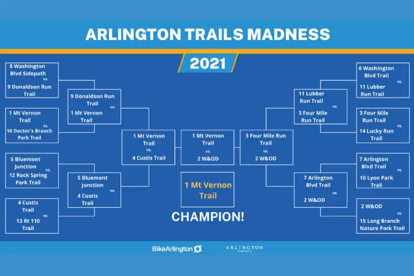
Arlington is home to 52 miles of off-street trails, so for two weeks in March and April 2021, the BikeArlington team ran daily polls on Twitter & Instagram to crown one Arlington Trail as a top trail in Arlington using a March Madness-style bracket. With so many amazing trails, it was a very competitive and fun tournament.
After nearly 2,400 votes, we narrowed down our field of 16 trails to 1, and Mount Vernon Trail was selected as the 2021 Arlington Trails Madness Champion. With each passing round, the polls got closer and closer, but ultimately in the final matchup, the Mount Vernon trail (MVT) defeated the W&OD trail by just 11 total votes.
While the MVT was ultimately victorious, the real goal of this light-hearted tournament was to highlight Arlington’s wonderful, beautiful, and well-connected trails. To keep the trail love going, we mapped out GPS routes for you so you can ride any of the trails that made it into our tournament.
Discover Arlington’s Trail Network
The Mount Vernon Trail (MVT)
As the 2021 trail champion, MVT spends just over 5 miles in Arlington following along the edge of the Potomac River. The MVT makes up a major section of the Arlington Loop (a 16-mile loop of trails separated from vehicle traffic and encircling much of Arlington) and is also a part of the much larger East Coast Greenway. Take the MVT to connect to the Four Mile Run Trail, National Airport, 4 different bridges into Washington D.C., and the Custis Trail. Google Maps| Ride with GPS
Washington & Old Dominion Trail (W&OD)
The runner-up, W&OD trail, stretches nearly 6 miles through Arlington and finishes 45 miles away in Purcellville, VA. The W&OD is also part of the Arlington loop and connects to the Four Mile Run Trail, Bluemont Junction Trail, and Custis Trail. Two easy access points to the W&OD are found near Shirlington and East Falls Church. Google Maps | Ride with GPS
Four Mile Run Trail
A third section of the Arlington Loop, the Four Mile Run Trail follows along 7.5 miles of the Four Mile Run stream through Arlington. This beautiful trail connects to Potomac Yards, the MVT, and the W&OD. Google Maps | Ride with GPS
Custis Trail
Our final section of the Arlington loop, Custis Trail follows I-66 for 4.5 miles and connects the W&OD trail to the MVT. It is also a good trail to access the Rosslyn-Ballston corridor. Google Maps | Ride with GPS
Bluemont Junction
Looking for an easy connection from Ballston to the W&OD? Look no further than the Bluemont Junction Trail. This 1.2 mile connector trail is a fantastic route to cut across the County and connect your ride. Google Maps | Ride with GPS
Washington Blvd Trail
Want to get from South to North Arlington quickly and easily? The Washington Blvd trail is your route. This mile-long trail connects Columbia Pike to Rt. 50 and the Arlington Blvd. Trail. It is an essential piece of the Arlington trail network. Google Maps | Ride with GPS
Arlington Boulevard Trail
The Arlington Blvd. Trail stretches for 2.5 miles from Rosslyn to Glebe Rd. along Rt. 50 and is a great trail for traveling east-west across the county. Google Maps | Ride with GPS
Washington Boulevard Sidepath
This under-the-radar trail is a great connection from Columbia Pike to Memorial Bridge. The trail is a mile in length, much of which is along the west side of the Pentagon. Google Maps | Ride with GPS
Donaldson Run Trail
A beautiful trail through the woods, the Donaldson Run trail is a charming but hilly connection from Marymount University to Military Rd. Google Maps | Ride with GPS
Lyon Park Trail
Often referred to as the “Secret Trail,” the Lyon Park Trail is a small but mighty connection from the Lyon Park neighborhood to the Arlington Blvd. and Washington Blvd. trails. Google Maps | Ride with GPS
Lubber Run Trail
The Lubber Run Trail is a peaceful escape in Arlington Forest that connects N George Mason Dr. to Rt 50. Google Maps | Ride with GPS
Rock Spring Park Trail
Like the Lubber Run Trail, the Rock Spring Park trail is another quiet, wooded trail that connects N George Mason Dr. to Little Falls Rd. Google Maps | Ride with GPS
Route 110 Trail
Looking to connect from Rosslyn to the National Mall? The Rt 110 trail is perfect for this. Connecting the US Marine Corps War Memorial to Arlington Cemetery and Memorial Bridge, this short trail is a great connection for getting to/from DC. Google Maps | Ride with GPS
Lucky Run Trail
Lucky Run Trail follows along S Walter Reed Dr. and provides an easy connection to the Four Mile Run Trail. Google Maps | Ride with GPS
Long Branch Nature Park Trail
The Long Branch Nature Park Trail features many spur trails that provide easy connections from the Four Mile Run & W&OD trails to the Forest Glen neighborhood and S. Carlin Springs Rd. Google Maps | Ride with GPS
Doctor’s Branch Park Trail
Last but not least, the Doctor’s Branch Park Trail provides a quick little shortcut from Randolph Elementary School and S Quincy St. to S George mason Dr. Google Maps | Ride with GPS
Use Our Bike Maps To Explore Arlington
Find all the Ride with GPS routes here and explore the entire Arlington biking and trail network with our 2021 Bike Map and Bike Comfort Level Map.
About the Author